Brian Hooker shared images of the maps where his wife Lynette Hooker fell overboard with friends and investigators. When they reached this deadly area, everyone was shocked to find a relic left behind by Lynette Hooker, floating on the surface of the sea
THE MAPS OF A GHOST SHIP: BRIAN HOOKER’S NAVIONICS SCREENSHOTS PROVIDE THE MOST DETAILED—AND DEBATABLE—ACCOUNT OF THE NIGHT LYNETTE VANISHED
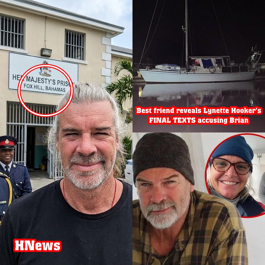
MARSH HARBOUR, THE BAHAMAS – As the search for 55-year-old Michigan native Lynette Hooker shifts from a rescue operation to a haunting recovery mission, a new set of digital evidence has surfaced, offering a rare, frame-by-frame look at her husband’s version of the tragedy. Brian Hooker, 59, who was recently released from Bahamian custody without charges, reportedly spent the days following his wife’s disappearance sharing marked-up GPS screenshots with friends, fellow boaters, and law enforcement.
These images, obtained by CBS News and analyzed by maritime forensic experts, purportedly show the route of the couple’s 8-foot hard-bottom dinghy on the night of Saturday, April 4. While Brian Hooker maintains these drawings were created to “help the search and rescue team,” investigators are now scrutinizing the metadata and the geometry of the route to determine if these maps are a guide to the truth—or a blueprint for a calculated deception.
The Digital Trail: Navionics and the 4-Mile Gap
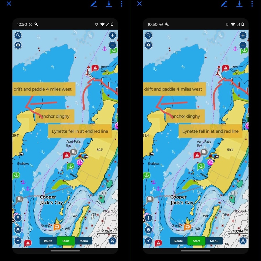
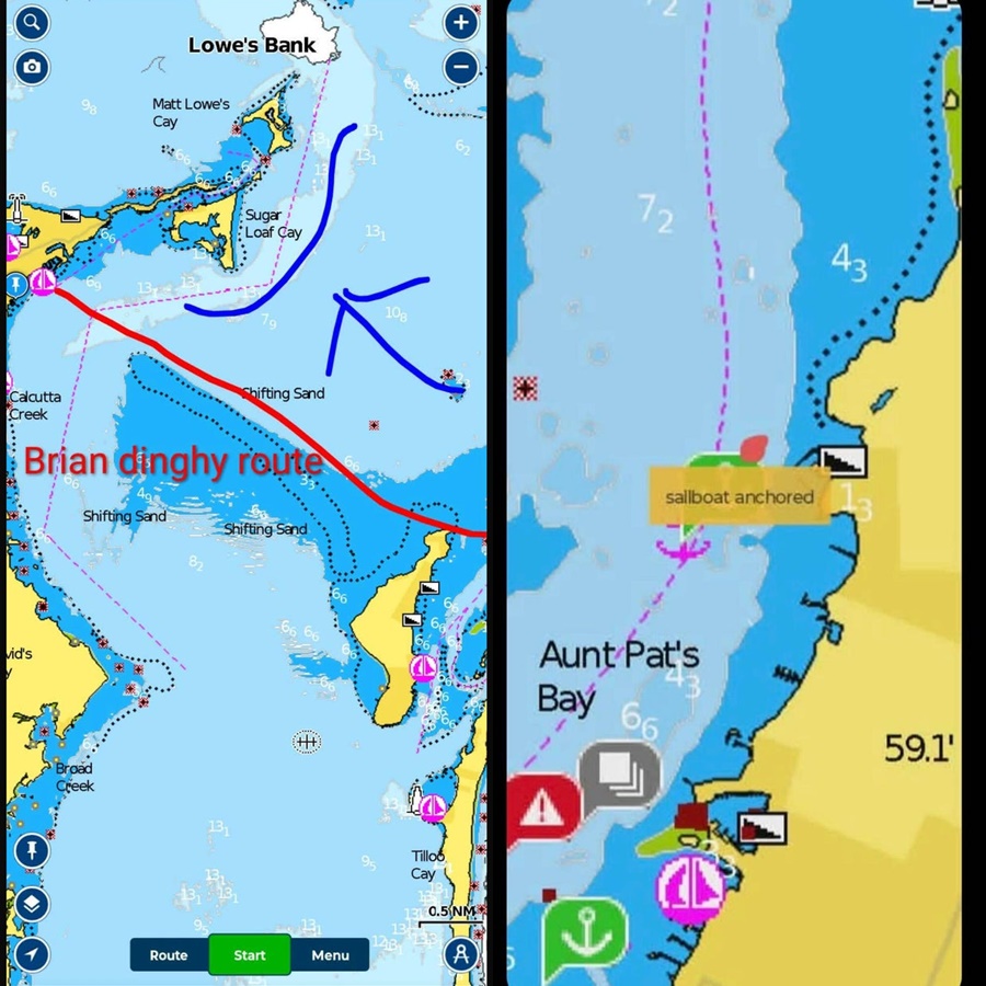
The evidence consists of multiple screenshots from Navionics, a popular GPS navigation app used by sailors to track depth, currents, and coordinates. On these digital charts, Brian Hooker used a drawing tool to plot the alleged movements of their vessel.
According to Brian’s account documented in these images, the nightmare began at approximately 7:30 p.m. at a point near Elbow Cay. It was here, he claims, that Lynette fell overboard into “unpredictable seas and high winds.” However, the maps reveal a startling detail: after the point where Lynette is alleged to have gone into the water, the dinghy traveled an additional 4 miles west.
For search and rescue teams, this 4-mile distance is the center of the mystery. Brian Hooker told investigators that because Lynette was wearing the engine’s safety lanyard, the motor shut off immediately when she fell. This leaves a glaring question: How did a powerless, 8-foot dinghy—weighted by a grown man—travel 4 miles across the choppy Sea of Abaco to reach the Marsh Harbour Boat Yard by 4:00 a.m. the next morning?
Eight Hours in the Dark
The timeline plotted on these Navionics maps creates a harrowing eight-hour gap. If Lynette went overboard at 7:30 p.m., and Brian did not wash ashore until 4:00 a.m., there is nearly a third of a day unaccounted for.
“The images may provide the most detailed account of Brian Hooker’s version of events that night,” notes one legal analyst, “but they also create a rigid framework that his defense must now justify.”
Brian claims he spent those hours “paddling desperately” against strong currents and high winds. Yet, maritime experts point out that the prevailing winds that night should have pushed a drifting vessel in a different direction than the one marked on Brian’s map. The precision of the “purported route” suggests the dinghy was under controlled navigation for at least part of that journey—a direct contradiction to the “powerless drift” story.
The Reaction from Authorities and Rescue Teams
When approached by CBS News regarding the validity of these hand-drawn maps, Hope Town Fire and Rescue declined to comment, citing the “ongoing and sensitive nature” of the investigation. The Royal Bahamas Police Force similarly remained tight-lipped, though sources indicate the digital forensics team is comparing Brian’s hand-drawn screenshots against the raw GPS data stored on his phone and the Navionics cloud servers.
If the raw data shows the engine was running during that 4-mile westward trek, Brian’s “safety lanyard” story would be proven false. This digital “he-said, app-said” scenario is why the U.S. Coast Guard has opened its own separate criminal investigation into the matter.
A Pattern of “Helpfulness” or “Direction”?
To Brian’s friends, the sharing of these maps was seen as the act of a grieving, proactive husband. “He told us he wanted to narrow the search area so they could find her faster,” said one boater who received the images.
However, in the world of criminal profiling, this is often referred to as “interfering by helping.” By providing his own maps, Brian effectively dictated where the search teams should—and shouldn’t—look. If he wanted to steer rescuers away from a specific coordinate where an incident actually occurred, providing a “purported route” would be the most effective way to do so.
This “helpfulness” stands in stark contrast to the testimony of Lynette’s daughter, Karli Aylesworth. She has consistently argued that her mother, a lifelong sailor who “grew up on the water,” would not have simply fallen overboard. To Karli and Lynette’s mother, Darlene Hamlett, the maps are just another layer of the “Soulmate” facade.
The Weight of the Evidence
While Brian Hooker denies any wrongdoing and his attorney, Terrel Butler, insists he is “heartbroken and deeply distressed,” the Navionics screenshots remain a permanent record of his claims.
As the case moves forward, these maps will likely be the cornerstone of the prosecution’s argument if charges are eventually filed. They represent a man who, in the immediate aftermath of losing his wife to the sea, was composed enough to open a navigation app, draw a complex route, and distribute it to the media and friends.
For the family in Michigan, these digital drawings are not a map to Lynette—they are a map of Brian’s mind. And as the 4-mile gap remains unexplained, the “strong currents” Brian blames for his wife’s disappearance are now the very thing pulling his own story apart.
The Sea of Abaco keeps many secrets, but in the age of Navionics and GPS, the truth has a way of floating to the surface. For now, the maps show a route to Marsh Harbour, but for Brian Hooker, they may eventually lead straight back to a prison cell.